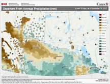
It’s too soon to tell if flooding will occur this spring, but heavy snowfall on saturated ground has communities in southwestern Manitoba watching the weather warily.
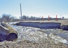
Residents around Wawanesa had a reminder last week of what that combination can do — a 10-metre-high riverbank collapsed on the Souris River just south of the village January 31, filling the river with the landslide.
It cut a fibre optic cable temporarily cutting off Internet and phone service to Glenboro and Cypress River.
Municipality of Wawanesa-Oakland Mayor Dave Kreklewich said they’ll be keeping a close eye on it, but expecting as spring rolls in, the river will wash the dirt away itself.
Read Also
YEAR IN REVIEW: 2025 a year of weather extremes
Wildfires, drought and flash floods, oh my! Looking back at the year’s headline-grabbing events in Canada and around the world.
“Once the spring thaw comes all the dirt will pass through into the river system,” he said.
- Read more: Province warns of flood risk
- Read more: Farmers watch nervously as moisture piles up
Meanwhile they’ll be watching that thaw closely in case it also brings overland flooding, Kreklewich said. Most people expect there will be some, he said. It’s just a question of how much.
“We’ll see what happens with the amount of moisture and see how it melts but we’ll be ready for it if anything happens,” Kreklewich said.
They do feel better prepared in the village than on previous springs, he added. After historically high levels of flooding in 2011, both Wawanesa and Souris had permanent dikes built.
But no dikes protect places farther to the west, like Pierson, and residents and surrounding farms in that area remain vulnerable.
In the Municipality of Two Borders, bordering the Saskatchewan and U.S. border, they just hope weather stays favourable but are preparing forthe worst, said Reeve Debbie McMechan who describes flood preparation out that way as “a bit of a fire drill.”
Their public works crew has already begun ensuring it will have enough road closed signs if needed and it has begun to review the emergency response plan, she said.
“This is a road we’ve been down before,” she said.
The area around Melita and Pierson were among the worst hit anywhere in Manitoba in 2014. Manitoba declared a provincial state of emergency July 4 after prolonged flooding was followed by a deluge over the long weekend that summer.
McMechan said she thinks their area is somewhat better prepared to handle another flood now, but there’s only so much they can do.
“It seems like there’s not a lot you can do,” she said. “The floods we’ve had in past years have been so unpredictable. The flood patterns have been in different areas… ravines have sprung to life, that have given us problems where we haven’t expected them.”
“It’s a lot of waiting and wondering,” she added.
The RM of Pipestone, which also saw extensive damage to municipal roads and bridges and flooded-out farms, is also in early stages of preparation for a repeat too. It is currently doing an inventory of sandbags and reviewing the emergency response plan, its council head said last week.
Right now there’s just a lot of uncertainty as to what to expect, said Reeve Archie McPherson.
“Spring is quite a ways away yet.”
Oakland-Wawanesa, Two Borders and Pipestone are all in the Souris River sub-basin, an area the province says is of particular concern this year due to heavy winter snowfall on top of saturated soil conditions.
Worries have intensified since an earlier-than-usual provincial flood forecast, issued at the end of January, that said with future unfavourable weather conditions the southwest region together with the Souris, Red, Pembina, Lower Assiniboine and Roseau river areas are currently at risk of major flooding.
What actually happens, however, depends on what the weather does over February and March.
The severity of spring flooding will be contingent on the speed of the snowmelt, the depth of frost in the ground, and river and lake levels prior to the spring run-off.
That’s why everyone is worried about overland flooding in the Boissevain and Deloraine areas too.
Aaron Vanbeselaere, interim manager for the Turtle Mountain Conservation District said he’s hearing lots of worry about overland flooding by those around Whitewater Lake.
“It’s far more full than it historically has been, and for every inch that lake goes up in elevation it goes out 20 feet,” he said,adding that excess precipitation has already pushed it to levels currently six feet higher than average.
“It’s caused a lot of concerns into Deloraine and Boissevain,” he said.
At the West Souris Conservation District, GIS technician Scott Hainsworth said he’s heard from worried local landowners too.
“People are upset about more water coming,” he said. “I think there’ll be a lot of local meetings going on.”
The first full provincial flood outlook is expected at the end of this month.


