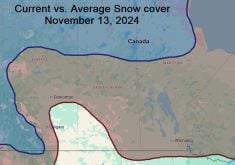
This map is created by Environment Canada but I do a fair bit of tidying up of the data displayed to make it
easier to read. Because of this, the data on the map should be seen as giving you a general idea of how much
snow there is across the Prairies. Overall snow cover across the Prairies is fairly deep compared to previous
years, with a large portion of the region near or above 25 centimetres.