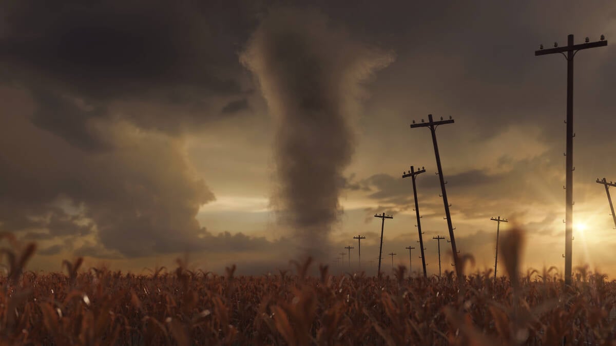
Let’s begin our look at what is both the most destructive and awe-inspiring weather phenomenon we see across the Prairies — tornadoes — with a look at some close relatives.
As I looked back at what I have written about this in the past and went over some of the more common conversation I have heard regarding the topic, I decided we should do a little crash course on what I am calling whirlwinds and atmospheric vortices.
If our air didn’t spin, we wouldn’t have weather. These spinning columns of air appear in many forms, from large scale circulations such as areas of high and low pressure, to all sorts of much smaller scale rotations that range from harmless fair-weather whirls to devastating tornadoes.
Read Also

VIDEO: What climate change data gets wrong about the Prairies
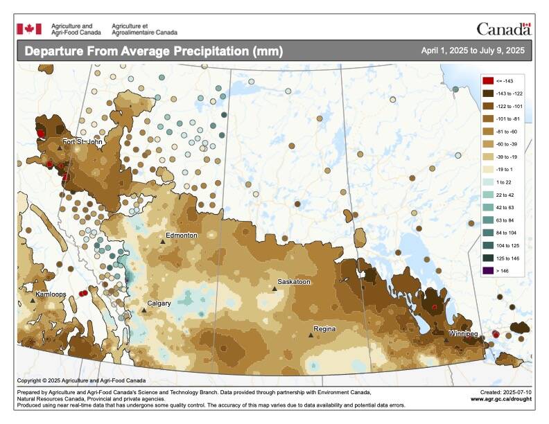
Precipitation, not temperature, may be a better gauge of climate change impact on the Prairies, says director of the Prairie Adaptation Research Collaborative.
Although they all involve rotating air and are visually similar in some respects, their formation mechanisms, environments and intensity vary widely.
What we are going to look at in this issue is an in-depth explanation of five such spinning air phenomena: dust devils, cold-core funnels, waterspouts, landspouts and tornadoes, with particular focus on the first four.
I decided to do this as there is often a fair bit of confusion between these different events.
Dust devils
Dust devils are small, short-lived whirlwinds that occur on clear, hot days, most often over dry ground. They form at the surface when intense sunlight heats the ground, warming the air just above it. The hot surface air rises quickly through the cooler, denser air above, creating a localized updraft. If there’s a slight horizontal breeze or uneven heating, this rising column can begin to rotate.
They can range from less thana metre in width up to 30 metres and while usual only reaching several metres in height, they have been known to extend upwards of 1,000 metres on rare occasions. These dust devils, as the name implies, are often visible because of the dust, sand and debris picked up from the ground.
When no debris is available, these rotation columns of air can take you by surprise. I remember once sitting by my pond when a dust devil cut across the pond — it looked like and invisible toy motorboat.
Wind speeds inside a strong dust devil can reach 50 to 90 km/h which is enough to throw light objects around, but they are not dangerous to structures. Dust devils don’t require a thunderstorm or large-scale weather system — they are purely driven by surface heating and localized turbulence. The best chance of seeing dust devils is in the spring.
Cold-core funnel clouds
Next up, cold-core funnel clouds. These clouds are narrow, funnel-shaped clouds that sometimes extend from the base of a cloud during cool, unstable weather. They’re often mistaken for weak tornadoes but are generally harmless.
These whirlwinds develop in environments with a cold upper atmosphere and strong low-level instability, often behind a cold front or beneath an upper-level low-pressure system. The steep temperature difference between cold air aloft and warmer air below creates buoyancy and turbulence, which can sometimes organize into small vortices.
They usually appear as thin, wispy funnels descending from a cumulus or stratocumulus cloud and are usually short-lived and rarely if ever reach the ground. Typically, they are too weak to produce damage but on rare occasions if they do touch down they may create a very weak tornado-like effect for a very short period of time.
While associated with cumulus clouds they are not related to supercell thunderstorms, and their rotation is usually weak and shallow compared to true tornadoes.
These first two whirlwinds are the most common types we see across the Prairies. For those of you who are near large bodies of water (mostly Manitoba) our next whirlwind is the waterspout.
The spouts
Waterspouts are rotating columns of air and mist that occur over water. They are more common than tornadoes globally, especially in tropical and subtropical regions. There are two types, fair weather and tornadic.
Fair-weather waterspouts form in light wind and high humidity over warm water. These can form under weak thunderstorms or even cumulus clouds. They are typically slender ranging form white to translucent. They range from 10 to as much as 100 metres across and often exceed 1,000 metres. They usually only last for about five to 10 minutes with wind speeds in the 80 to 150 km/h range.
The tornadic waterspout is exactly what it sounds like, a tornado over water. These occur when a strong thunderstorm produces a tornado, and it just happens to cross a water body.
The last whirlwind, before we get to tornadoes, is the landspout. Landspouts look similar to tornadoes but form differently and are generally weaker.
Unlike a classic tornado, which is connected to the rotation of a powerful thunderstorm, a landspout forms when a pre-existing near-surface rotation is stretched upward by a growing cumulus cloud’s updraft. Landspouts tend to be narrow and rope-like or tube-shaped funnel and are usually weaker and shorter-lived than tornadoes. They are usually only 10 to 50 metres in width with a height of a few hundred metres.
While not a true tornado, their wind speeds can still reach up to EF1 intensity, which is about 140 km/h, but most are weaker. While weak, they can still kick up dust and debris, making them visible, and they can cause minor damage or injury if strong enough.
The real thing
Finally, we reach tornadoes. Tornadoes are the most intense of these phenomena, capable of catastrophic destruction.
They are associated with powerful rotating thunderstorms called supercells, with organized, deep convection. Wind speeds can exceed 300 km/h, with the potential to destroy buildings, hurl debris and carve long paths of devastation.
In our next issue we will spin our way into a detailed look at our current understanding of this destructive and difficult to understand whirlwind.