The Weather Vane is prepared by Daniel Bezte, a teacher by profession with a BA (Hon.) in geography, specializing in climatology, from the University of Winnipeg. Daniel has taught university-level classes in climate and weather and currently operates a computerized weather station at his home near Birds Hill Park, on 10 acres he plans to develop into a vegetable and fruit hobby farm.
Contact him with your questions and comments at[email protected].
After a hot, muggy start to this forecast period it looks like the weather will become more comfortable. The ridge of high pressure that brought the mainly sunny skies and hot, muggy conditions earlier this week has pushed off to the east. In its wake we will see an area of low pressure move in starting on Thursday.
Read Also

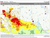
June brings drought relief to western Prairies
Farmers on the Canadian Prairies saw more rain in June than they did earlier in the 2025 growing season
This low is forecasted to be fairly large, but not well defined, which means we will likely see a mix of sun and clouds along with a good chance of showers and thunderstorms. It currently looks like Friday will be the cloudiest and wettest day.
This low is forecasted by the models to move to our northeast and intensify over the weekend and will place us in a fairly strong northerly flow behind the low. This will drop our high temperatures back down to the low 20s over the weekend. With cooler air moving in, especially in the upper atmosphere, we will likely see plenty of afternoon clouds along with a few scattered thunderstorms.
For the first half of next week it’s looking like we’ll be stuck between systems. There will be a strong, fairly stationary area of low pressure over Hudson Bay, along with a large ridge of high pressure building over Western Canada. This will place us in a northwesterly flow resulting in comfortable mid-August temperatures. We should see plenty of sunshine along with highs in the low to mid-20s and overnight lows around the 10 C mark.
Usual temperature range for this period: Highs: 20 to 29 C Lows: 8 to 15 C


