There has been a lot going on in the weather across Western Canada, with record rains in British Columbia, fairly early and significant snows across much of the Prairies, and global temperatures still running warm despite La Niña. So, in this article I will go over the latest global temperatures and take a look at just how much rain and snow fell across Western Canada.
Let us begin with global temperatures. The October numbers are in and, according to both NASA and NOAA, October 2021 was the fourth-warmest October on record since accurate global records began in 1880. NOAA reported October came in 0.89 C above the 20th-century average, while NASA reported a value that was 1.23 C above average. NASA’s anomaly is based on the years 1880-1920, which is considered a period of pre-industrial temperatures.
Comparing land temperatures to ocean temperatures, October saw land temperatures that were the third warmest on record, with ocean temperatures coming in fifth warmest. Not surprising, the ocean temperatures were “cooler” compared to average relative to the land temperatures, given the development of La Niña conditions across the Pacific. What was notable was that land temperatures in the Northern Hemisphere were the warmest on record in October, with North America experiencing its second-warmest October. I couldn’t find numbers for Canada, but since the United States came in as the sixth-warmest October, and North America had its second warmest, Canada must have had either its warmest or second-warmest October on record.
To wrap up this section, according to the National Center for Environmental Information annual temperature outlook, 2021 is likely to come in as the sixth-warmest year on record. This shouldn’t be taken as hopeful as this was a La Niña year, which usually results in cooler global temperatures.
Ground measurements
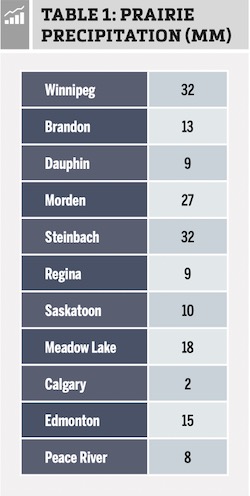
OK, moving on to the wet and snowy weather we have seen and read about across much of Western Canada over the last couple of weeks. Thanks to a couple of strong storm systems, a good portion of the Prairies received some much-needed precipitation during this period, most of which fell as snow. The problem with the snowfall is that in some areas a fair bit of melting occurred during and just after the snowfall, and in other places the wind whipped the snow around so much that it made ground measurements difficult. Therefore, the precipitation totals are in millimetres of water-equivalent precipitation. The largest amounts were reported in Manitoba, and while the totals might not seem that impressive in Saskatchewan and Alberta, any early-winter snow is appreciated. Table 1 shows some of the precipitation totals starting in Manitoba and moving westward.
Now, if we continue westward into British Columbia, this is where we do find some truly astounding precipitation totals. While this part of the world is known for its rainy winters, extreme rainfall events like the one seen on Nov. 13 to 15 are extremely rare. Environment Canada lists this event as a one-in-50-year to one-in-100-year event. Table 2 shows some of the rainfall totals from the storm (first number) along with how much total rain has fallen this November, up to and including Nov. 17 (second number).
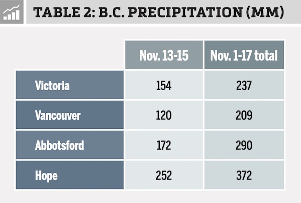
I could go on; according to Environment Canada as many as 24 locations received more than 100 mm of rainfall during this period. What caused all this rain over such a short period of time? A weather phenomenon known as an atmospheric river. The west coast of North America usually sees a couple of atmospheric rivers develop each year. They are almost exactly what they sound like: a flow or channel of air coming in off the Pacific Ocean that contains very high levels of water or humidity. These rivers can get pulled into storm systems, providing a lot of moisture to fall as either rain or mountain snows. Typically, these rivers come ashore south of British Columbia, bringing much-needed rains and snows to California, but conditions this time around pulled one of these flows of deep moisture northward, resulting in the extreme rainfall. Our hearts and prayers go out to everyone who has been affected by this weather event.
That’s about it for this issue; not sure what’s up for next week. If you have any weather- or climate-related questions you can reach me via email. Now get out there and enjoy what has been reported as one of the earliest starts to the cross-country ski season in a long time!