The old weather pattern returns

Issued: Monday, June 29, 2015 – Covering: July 2 – July 8, 2015

Our overall weather pattern seems to have slipped back into the same general pattern that prevailed for much of the winter and spring. That pattern had a persistent ridge of high pressure over western North America and a trough of low pressure over eastern regions. We were stuck between these two main features and our

Roller-coaster ride settling into summer weather mode

Issued: Monday, May 25, 2015 – Covering: May 27 – June 3, 2015

You have to love spring across the Prairies. One day it’s cold and snowy and a few days later it feels like summer! It looks like our spring roller-coaster ride is going to continue, but it does appear the ride is coming to an end. After a beautiful weekend and first half of the week,


Weather forecast predicts an unsettled pattern developing

Issued: Monday, May 11, 2015 – Covering: May 13 – May 20, 2015

Late last week and into the weekend we experienced a classic example of a small change in a weather system that ended up having a big impact on the weather. A large area of low pressure moved up and passed through our region late last week as forecast, but the system ended up being a

Arctic high pressure continues to dominate

Issued: Tuesday, Feb. 17, 2015 – Covering: Feb. 18 – Feb. 25, 2015

Our weather over the last week was dominated by arctic high pressure as predicted, but those highs didn’t track quite the way the weather models indicated they would, resulting in only a mediocre forecast. This issue’s forecast begins where last week’s left off — with cold arctic high pressure dominating. The first and strongest of

Typical mid-winter weather

Issued: Monday, Feb. 9, 2015 – Covering: Feb. 11 – Feb. 18, 2015

It’s turning out to be quite the battle between cold air to our north and east and warm air to our west and south. Unfortunately, for those hoping for a return to mild melting weather, it looks like we stay on the cold side of things at least for the next week or two, as


Warm fall weather finally arrives

Issued: Monday, Sept. 22, 2014 – Covering: Sept. 24 - Oct. 1, 2014
It took a little longer than expected, as a secondary area of low pressure brought clouds and showers to most regions early last weekend, but a western upper ridge of high pressure is finally moving in, bringing with it much-anticipated warm, dry weather. This upper ridge will bring mainly sunny skies along with warm temperatures

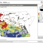
This map shows the total amount of precipitation that has fallen across the Prairies during the 30 days ending Aug. 25, as a percentage of the average expected for this period. This map seems to be a continuation of the maps we’ve seen so far this summer, with above-average amounts of rain over southern Alberta, Saskatchewan and western Manitoba and below-average amounts over northern Alberta.

Late summer/early fall weather

Issued: Monday, September 1, 2014 · Covering: September 3 – September 10, 2014
Last week’s weather ended up following its own rules as a relatively fast-flowing pattern developed across our region, bringing with it rapidly changing weather conditions. For this forecast period it looks like this weather pattern will persist. High pressure that started off this week will quickly be replaced by an area of low pressure that

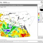
This map shows the total amount of precipitation that has fallen across the Prairies compared to historical averages over the 30 days ending Aug. 7. You can see just how dry it’s been across nearly all of agricultural Manitoba during this period; the only wet area was around The Pas. Farther west, much of northern and western Saskatchewan was wetter than average, as was east-central Alberta.

Off to a warm and dry start

Forecast issued Aug. 11, 2014, covering the period from Aug. 13 to 20, 2014
Only problem with last week’s forecast was that we saw two cold fronts move through last weekend instead of just one. The first moved through Saturday, bringing a few quick-moving thunderstorms. The second moved through on Sunday, bringing scattered clouds, the odd shower and cooler temperatures. Hopefully the forecast for this week will be as


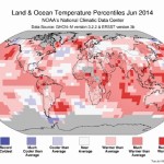
Usually we look at a map that has to do with precipitation, but I thought I would take a break from those maps and look at a map that shows the global temperature anomalies as determined by NOAA for the month of June. Looking at the map, the red-shaded regions saw above-average temperatures while those areas in blue were below average. As you can see, most of the map is red. June 2014 was the warmest June on record, according to NOAA.

A warm and sunny forecast

A boring forecast can be a good thing
It’s been awhile, but it finally looks like we’ll see a prolonged period of dry, warm summer weather. After yet another stronger-than-usual upper low moved across the Prairies last weekend, it looks as if our region will be stuck right in the middle of a blocking pattern. Two stationary areas of low pressure are expected

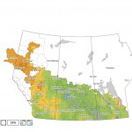
This map shows the total precipitation across the Prairies so far this growing season compared to the long-term average. Most of the Prairies have seen average to well-above-average amounts, with the wettest areas located in a northwest swath from Brandon to just west of Saskatoon.

Unsettled weekend but heat building in next week

Issued: Monday, July 21, 2014 · Covering: July 23 – July 30, 2014

The first half of last week’s forecast was pretty much spot on, as the forecasted trough of low pressure moved through our region last weekend bringing with it a mix of sun, clouds, warm temperatures and a few showers and thundershowers. For the first part of this forecast period high pressure looks to dominate, bringing