
Planting more forage would be valuable for flood control, and new research has numbers to back that up.
“We knew this from the start,” said Marcos Cordeiro, study lead and assistant professor of animal science at the University of Manitoba.
Previous research, such as a study based in Saskatchewan in 2003, had already flagged forage capability to draw off flood water, he noted.
Read Also
Manitoba canola variety trials axed
Industry reluctance killed the program designed to give farmers unbiased comparisons of seed performance across the province.
“The goal for us was to extrapolate this over a large area.”
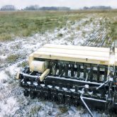
The study, which used hydrological modeling based on decades of data, looked to simulate how water and nutrient flows would change if cropland was converted into perennial forage on the Prairies.
Researchers wanted to see how flows behaved at the watershed level and whether there was variation when results were drawn over a longer period.
Most studies last only a few years, and results can be skewed depending on weather in that limited time. By using a modeling framework, Cordeiro said, “we can capture those wet and dry cycles and you can see how consistent the results are.”
The last part of the project, on nutrient flow, is still in the works.
“We need to get a handle on the hydrology first, because when the water moves, everything changes,” Cordeiro said.
Why it matters: Forage and grasslands have diminished on the Prairies as that land is converted to annual crops.
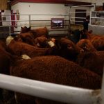
Although University of Manitoba staff took point on the project, it also included collaboration from the University of Saskatchewan and Agriculture and Agri-Food Canada and was funded through beef checkoff dollars.
Researchers focused on areas west of Winnipeg, within the La Salle River basin. A total 23 years’ worth of hourly weather and flow data was drawn from an Environment and Climate Change Canada monitoring site in the area.
Then, for each piece of land in the four sub-basins around that site, researchers gathered crop data via the Manitoba Agricultural Services Corporation.
The study then rolled that information together to tease out a hydrological model that considered the weather, crop growing traits at the time (plant height, water needs, etc.) and the impact of those crops on soil structure.
The tool could then be used to predict how streamflow would change if acres were shifted from grain crops to perennial forage.
Results
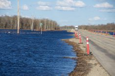
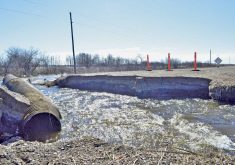
Farmers may not be shocked to learn that forage stands caught more snow than residue left from annual crops. However, those same forage stands also gave off less water come spring. Perennial forage saw an average 36 per cent less runoff compared to cropland, while overland flow across forage was 53 per cent lower.
That translated to a 30 per cent drop in peak daily discharges into the La Salle River compared to annual cropland.
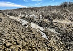
Part of that, researchers suggested, was more capacity for early-season ground to infiltrate water. Undisturbed soil with deep forage roots had better soil structure, was more porous and therefore had a leg up when it came to infiltration, and the study found that frozen ground with perennial forage infiltrated almost 67 per cent more when snowmelt came. There was also more evaporation and transpiration.
The study estimated that perennial forage lands absorbed two-thirds more water than annual cropland. Daily soil moisture, on average, was 18 per cent higher, although some years showed forage stands with lower daily soil moisture, depending on that spring’s snowmelt.
“It was nice to be able to put numbers,” to forage traits that industry and academics already knew about generally, Cordeiro said.
“There’s a lot of talk about grasslands. We felt that this was [an] important result to be out there and we received good feedback about this.”
As far as nutrient flow, grazing and harvesting impacts did not make their way into the analysis, although researchers hypothesized that removing forage would mean less nutrients leaching from plants at the surface. Manure or bale grazing would move the needle the other way.
Regardless, less runoff would mean less nutrients in that water and more nutrients staying in the field where they can be a benefit, the study said.
Economics of forage
The research was highlighted in a recent blog post from the Beef Cattle Research Council.
Outside of flood mitigation, the council said, cattle have also been used as wildfire prevention in parts of B.C. Carbon sequestration and wildlife habitat in wetlands and grasslands also featured in the council’s pitch for forage acres.
Commodity values will largely determine whether producers opt to seed forages, the council acknowledged, “but food service and retailers’ perceptions and government policies … and regulations can also influence markets and cropping choices.
“Solid, science-based information like this is important to support Canada’s beef and forage sectors’ ongoing efforts to share the positive, factual messages about the environmental benefits of beef and forage production in Canada.”
Cordeiro also noted that economic stress that may lead producers to convert forage land.
“What we’re trying to do here with these types of studies is to do some valuation of the grasslands,” he said.
“I think this is something that’s missing. You have to find a way to valuate those landscapes and be able to show that value so that producers … have some incentives to keep those landscapes.”
Where it fits
The study is not the only effort to get a handle on Manitoba’s hydrology or the impact of land use changes.
To the west is the Manitoba Forage and Grassland Association’s Aquanty project, which created five interconnected models in the Assiniboine River Basin. Those models have been used to predict the impact of different flood mitigation measures or land changes.
In a study within the Oak River-Shoal Lake Watershed, the project looked at how forage, grassland and wetlands affected both flood and drought management from 2009-16.
The Aquanty project then set its sights on a real-time hydrological forecasting tool for farm use. It later expanded that tool to include the Pembina Valley Watershed, its first foray into the Red River Basin.
The Red River Basin Commission in 2021 also completed LiDAR ground mapping. That information feeds into hydrological modelling and the region’s flood planning.
Cordeiro acknowledged the growing wealth of water data. There are efforts to gather even more information from data sets on soil and land use, satellite data and weather, he noted.
The Aquanty project, based in the rolling terrain of western Manitoba, has a much different model, Cordeiro said, although there is some geographic overlap with his work.
The University of Manitoba researcher plans to have results from the Birdtails Watershed, which was also the subject of a micro-analysis under Aquanty, later this year.
“It’s interesting to see how the models complement each other,” Cordeiro said. “The idea is actually to see how these tools can give a different angle to the same problem. For sure, we can try to see how the results compare.
“But I believe, for the most part, we should see consistent results in terms of hydrology for those landscapes.”