It’s time for our monthly weather roundup and a look at various forecasts, but first let’s look at the poles and a sea ice update for the Arctic and Antarctic.
At the end of June, arctic sea ice covered about 10.9 million square kilometres, which is the 12th fewest on record. Compared to 1979, the arctic has about two million fewer square kms of sea ice in June. Hudson Bay had well below average sea ice, with amounts at record lows. In the Antarctic, sea ice is also well below average, with a deficit of about two million square kms.
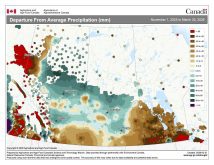
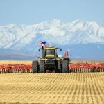
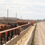
Now let’s look at the first month of summer across the Prairies. After near-average temperatures in May and average to well above average precipitation, the question for June was whether that pattern would continue. Now we know June had a continuation of May’s weather and many people asked me when it would start to feel like summer.
Read Also
VIDEO: Here’s Manitoba’s 2026 spring storm forecast
Weather models are calling for above-average precipitation in southern Manitoba, with at least two more Alberta clippers possible.
The number of days in June when daytime highs made it past 30 C show the unseasonal weather. Using only the main reporting stations from each province, Winnipeg was the only location to record a day above 30 C, when the daytime high hit 30.4 C on June 24. The warmest days in all other locations were in the 27 to 28 C range.
Let’s look at June in detail, starting in Alberta. All three locations reported mean monthly temperatures below the long-term average. Edmonton and Peace River had a mean monthly temperature around 12.7 C, which was about 1.5 C colder than average.
In Calgary it was a little warmer, with a mean monthly temperature of 13.6 C, only 0.1 C below average. Precipitation in June was near to slightly below average in both Calgary and Edmonton, with Calgary recording 83 mm and Edmonton 67. Peace River reported about 118 mm, which was well above the average of 66.
In Saskatchewan, we find the coldest temperatures compared to average. Both Regina and Saskatoon reported mean monthly temperatures of 13.7 C, which was 2.0 C below average in Saskatoon and 2.5 C colder than average in Regina.
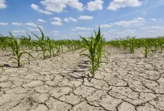
As is usual when you have below average temperatures in June, precipitation was well above average. Both locations reported around 110 mm, which is about 40 mm more than average.
Manitoba had the warmest monthly temperatures but they were still below average. Winnipeg was the hot spot with a mean monthly temperature of 16.5 C, which was 0.5 C below average. Brandon and Dauphin had mean monthly temperatures of around 15 C, about 1.0 C below average.
Brandon was the wet spot with 126 mm of rain, which is 45 mm above the long-term average. Winnipeg reported about 103 mm, or 15 mm more than average. Dauphin was the dry spot with a monthly total of 75 mm, which is slightly below average.
Overall, it was a cooler and wetter than average June across most of the Prairies. None of the forecasts predicted the lower temperatures and only the CFS model came close on the precipitation forecast.
My own forecast predicted similar weather as we saw in May, with near average temperatures and near to above average precipitation. Not perfect, but better than the other forecasts.
Let’s see if any long-range forecasts can do better with July and August. The Old Farmer’s Almanac calls for warmer than average temperatures in July and August, along with below average precipitation.
The Canadian Farmer’s Almanac calls for near average temperatures in July but mentions warm and cool periods. August looks to start with near-average temperatures but will turn cooler in the last half of the month. Its precipitation forecast leans toward above-average amounts with several instances of unsettled and stormy weather.
Looking at NOAA’s forecast and extrapolating it northward, it appears July and August will see above-average temperatures, with the warmest temperatures over western regions. Precipitation is forecast to be below-average in the west and near-average in the east.
The CFS model calls for a cool start to July, switching to above-average temperatures. These are then forecast to continue into August, with western regions the warmest compared to average. After a wet start to July, the model shows dry weather for the rest of the month. August’s forecast is for near- to above-average precipitation.
The CanSIPS model calls for below-average temperatures across the southern Prairies in July with only northern Alberta seeing above-average temperatures. July’s precipitation is forecast to be below-average over the northern half of the Prairies with near- to above-average amounts in the south.
In August, the model forecasts temperatures across the south at near to slightly below average, with above-average temperatures expected to continue in the north. Precipitation is forecast to be near to below average for the month.
The ECMWF calls for above-average temperatures in July and August, with the eastern half of the Prairies experiencing the warmest conditions. The precipitation forecast calls for near-average amounts and possibly below average over southern Alberta.
Here is my best guess. I lean toward the CFS model because there are strong indications that our weather pattern will switch into a much warmer pattern. These warmer-than-average temperatures will likely last into August. I expect precipitation will be near-average.