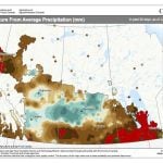
This forecast period starts with a broad, cool area of high pressure stretching across the Prairie provinces. The cool air combined with strong mid-summer sunshine is leading to partly cloudy skies along with the odd shower or thundershower.
More stable weather due to El Niño-Southern Oscillation (ENSO) neutral conditions are likely in the Northern Hemisphere summer of 2025, with a 56 per cent chance in August-October, the U.S. Climate Prediction Center said.
For this forecast period we are starting off with a large area of high pressure over Ontario and an equally large area of low pressure over the Yukon. The clockwise flow around the Ontario high, combined with the counterclockwise flow around the Yukon low, is creating a widespread southerly flow across the Prairies. This should lead to one more day of warm temperatures across the western Prairies and a couple more days over the eastern half.
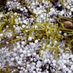
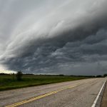
Hail is a common and potentially dangerous form of precipitation which is commonly seen during thunderstorms on the Canadian Prairies. But how does it happen?
For this forecast period we start, once again, with no strong systems impacting the Prairies. But, as we head into the weekend a strong area of low pressure is forecasted to develop over the western U.S. This low will impact our region over the weekend, but how and where is a little uncertain.
Weather columnist Daniel Bezte says Manitoba farmers can expect many thunderstorms every summer, but only some become severe, if they have all the right ingredients.