Ithought I would take a break from our look at severe summer weather and take a little bit of time to hit on a few other weather stories that have been taking place locally and around the world.
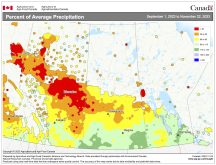
First of all, for us, comes the biggest weather story: what the heck is going on with our weather? After 11 months of above-average temperatures and below-average amounts of precipitation, it looks more and more like May will break the trend. After some fairly nice May weather it appears we just couldn’t dodge the May course of cold, wet weather. Fortunately for most of us, this year we went into May with warm, dry conditions. Most fields had been seeded and a lot of people were actually hoping for some rain, as long as we don’t get any ridiculous amounts and it doesn’t last for too long!
Read Also

Prairie weather all starts with the sun
The sun’s radiation comes to us in many forms, some of which are harmful to organic life while others are completely harmless or even essential, Daniel Bezte writes.
Well, if you take a look at the forecast, you’ll see it looks like these cool, wet conditions are over and more summer-like weather will be moving in. Now, on to the question of why we had a cold, wet, end to May. For the most part this weather can be blamed on a ridge of high pressure that built up over the eastern Pacific Ocean. This ridge forced the jet stream to ride up and over it and then, as the jet stream approached North America it came crashing down, diving all the way into the southwestern United States. At this point the jet stream recurves back to the east. This deep southern loop of the jet stream helped to create a trough of low pressure. It also allowed for plenty of cold air to be pulled southward.
Over the Pacific we had a setup that created a trough over western North America, while over eastern North America a second ridge of high pressure developed as the jet stream came out of the western trough and moved northeastward. This eastern ridge of high pressure acted like a barrier blocking any significant eastern movement of the western low-pressure trough.
Where does this place us? Right in the middle of the two! This is basically the path, or highway, that any areas of low pressure forming in the trough will follow. We saw one of these lows move through last week, bringing showers and thunderstorms, and a second stronger low move through over the weekend and into the early part of this week. The good news is that it looks like this pattern will break down during this week and we should see much nicer weather conditions move in.
Beryl and Bud
Elsewhere in the world, it has been an early and active start to the hurricane season. Over the Atlantic and Caribbean the formation of sub-tropical storm Beryl marks the first time since 1908 that two named storms have formed so early in the year. Also, to the west, over the eastern Pacific, Hurricane Bud’s formation on May 21 marked the earliest in the season that two named storms have formed in this region. Hurricane Bud, which had a peak strength of Category 3, has also set a record for the strongest hurricane so early in the season and tied the record for strongest May hurricane. We’ll have to keep a close watch on the tropics this year to see if this is a harbinger of things to come.
Now let’s go north, way north, and see what has been going on with Arctic ice cover so far this year. The extreme cold weather that Alaska, and the region around it, experienced this winter allowed for plenty of ice to develop in the Bering Sea. This increase in sea ice offset lower-than-average sea ice conditions in the waters north of Scandinavia and eastern Russia. By the time April rolled around, the extent of Arctic sea ice was only slightly below the long-term average for that time of the year. Late April and early May brought much warmer conditions to the Arctic, and the Arctic saw a period of rapid ice melt. Ice amounts by the third week in May fell back to around two standard deviations below the long-term average and were only a little shy of the all-time record low for the month, set in 2007.
Predicting the amount of sea ice that will melt this summer is a very difficult thing to do as weather patterns over this region play such a big role. Scientists point out that the amount of multi-year ice in the Arctic continues to decline. Ice that’s four years old or older used to make up about 25 per cent of the total sea ice; it now comprises only about two per cent of the total. About 75 per cent of the ice cover in the Arctic is now first-year ice, which is very susceptible to summer melt.
Next week we’ll take a look back to see what the final numbers for May will be, then we’ll look ahead to see what the weather might have in store of us for June and the rest of the summer.


