Two locations on the Prairies received significant rainfall last week and there have also been extreme rainfall events in several locations across the globe this September.
So, I will postpone our look at weather stations and take a closer look at what’s up with all this rainfall.
We will start with the global perspective and then zoom in on the Prairies and the relatively heavy rainfall over east-central Alberta and western Saskatchewan, and some very heavy rainfall in southeastern Manitoba.
Read Also

Forecasting spring 2026 weather on the Prairies
What weather can farmers expect across Manitoba, Alberta and Saskatchewan as they head into seeding? Plus: a lesson on what makes the seasons turn
Three regions had extreme rainfall and flooding over the past few weeks across the globe. In northwest and north-central Africa, unusually persistent and heavy rains caused severe flooding in an area that is usually very dry. In fact, parts of the Sahara Desert and Sahel belt have seen significant rainfall.
Satellite imagery shows dry lakes, which almost never have water, filling up. An unusual northward shift in the tropical rainfall belt over equatorial Africa drove this event.
The second area of extreme rainfall was across much of central Europe, as an unusually strong upper low dropped southward into Europe, which helped spawn an area of low pressure over the Mediterranean. This low, Storm Boris, pulled plenty of warm moist air northward into Europe, thanks in part to record-setting sea temperatures over the Mediterranean.
The push of moisture northward into the cold upper low, plus lift from mountains, help wring out this moisture, leading to rainfall totals pushing 400 millimetres in some areas. Some areas in Poland, for example, saw triple the previous record total rainfall for September.
Also of interest, this storm brought reports of as much as 145 centimetres of snow over high elevations of Austria, a record high amount from a September storm.
The third area of extreme rainfall was in Vietnam, where Typhoon Yagi made landfall on Sept. 7 as a category 4 storm. This was the first category 4 storm to hit this region since modern record keeping began in 1945.
So, while extreme rainfall from typhoons is not unusual, having this strength of a typhoon in the region is unusual. Reports indicate the typhoon did as much as US$2 billion in damage, and at least 291 people died. This same typhoon tracked into China, where damage estimates in Hainan province are reported in excess of US$11 billion.
Closer to home, three rainfall events hit our part of the world.
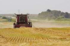
In southeastern and east-central regions of Alberta, widespread amounts of 40 mm to more than 65 mm were reported. This was thanks to a blocking pattern across North America that resulted in areas of low pressure slowly lifting northward into the Prairies, instead of moving relatively quickly to the east or northeast. These rains fell on Sept. 12 and 13.
A few days later, on Sept. 17 and 18, a second area of low pressure lifting northward brought significant rain to much of western Saskatchewan. Amounts from this system were upwards of 65 mm.
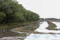
This same setup resulted in heavy flooding rain across southeastern Manitoba on Sept. 16 and 17. These rains were the result of a stalled boundary that brought several rounds of thunderstorms that tracked southwest to northeast.
Several storms across the same region, combined with fairly slow motion and unusually high levels of atmospheric moisture for this time of year, resulted in rainfall amounts exceeding 150 mm in some places.
The unusually high levels of atmospheric moisture have helped fuel all these extreme rainfall events. It is a simple fact that the warmer the atmosphere, the greater amount of water vapour it can hold. You just can’t argue with this. With higher global temperatures and warmer world oceans, more water vapour will make it into the atmosphere.
Scientists who measure total precipitable water vapour in the atmosphere reported that August had the highest amount on record, and it was the 14th consecutive month with record levels of atmospheric moisture.
I know someone will ask this question: If there are record amounts of atmospheric moisture, why do we still see extreme drought, either at different locations or at different times of year?
While a warmer atmosphere can hold more moisture, it also means those higher temperatures and increased ability to hold moisture result in an atmosphere that is also very good at pulling moisture from landscapes. This leads to what climate scientist have been talking about for over a decade.
As global temperatures increase, we will continue to see more swings from very dry conditions to very wet conditions — as if farming is not tough enough already.