Ithink the first thing I need to point out is that the usual temperature range for this time of the year is now getting warmer, which means we are past the middle of winter and heading toward spring!
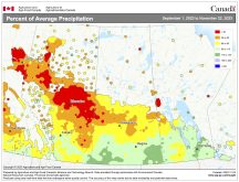
That is pretty much how this forecast looks. It doesn’t look like the overall pattern we’ve been in this winter will change much during this forecast period, as the models show plenty of mild air and little in the way of precipitation, be it snow or rain.
Read Also

Student agronomy challenge coming to Assiniboine College
The Prairies’ first agronomy competition brings together post-secondary ag students for hands-on crop advising challenges at Assiniboine College in Brandon, Man.
As has been the issue with nearly all of the forecasts this winter, it is not what type of weather we will see, but rather, just how extreme it will be and how the timing of these systems will work out. Currently the weather models show a ridge of high pressure building over the western U.S. and southern Canada, slowly sliding east during the first half of this forecast period. This will result in continued warm temperatures right through the weekend, which is not only well above the long-term average, but well beyond the usual temperature range.
For next week, the models show the western ridge of high pressure re-establishing itself while a strong area of low pressure stalls out over northeastern Canada. This will place us in a northwesterly flow and, depending on the exact position of these two features, we will likely see cooler temperatures as colder air backs in from the northeast. The coldest temperatures will be seen in northern and eastern sections, while the southwest will be the warmest. By Wednesday we should expect to see highs in and around the -10 C range, with overnight lows around -20 C.
Usual temperature range for this period: highs, -21 to -5 C; lows, -32 to -14 C.


