Reuters – After years of punishing drought in some areas, many farmers in Australia’s east were hoping the newly declared La Niña event would bring them good rains.
Many are now rejoicing, after the wettest November experienced in Australia for more than two decades. But for some farmers, heavy and prolonged rain is causing a new set of problems.
Last year’s La Niña delivered good rainfall in some areas – while leaving others drier than they would have been under an El Niño, with many areas in southern Queensland missing out. In La Niña years, the cattle-farming town of Roma receives an average of 247 mm from November to the end of January. Last year it only got half that.
Read Also

Why is the sky blue?
The colour of the skies, on the Prairies and elsewhere, tells the story of the paths sunlight takes as it enters Earth’s atmosphere, Daniel Bezte writes.
This year’s La Niña has already delivered rain to many areas left dry last year. Roma, for example, has received more than 200 mm in November 2021 alone. These large rainfall events and seasons are required after ongoing drought to recharge the moisture in the soil.
But continued rain will be less welcome in newly waterlogged areas along the Queensland and NSW border and the Northern Rivers region, given it may lead to further flooding.
Seasonal forecasts give a greater than 60 per cent chance of rainfall above the median for much of eastern Australia from now to the end of March.
If this summer of rain eventuates, it will be welcome news for many farmers in eastern Australia who have had below-median rainfall for three or more years.
Farmers usually welcome La Niña with open arms, given plentiful rainfall can boost production and profits.
Still, a boon for one industry can be a burden for another, with heavy or prolonged rainfall able to damage fruit and delicate crops as well as delaying harvests or making them more challenging. Flooding can wash away entire fields and damage roads and other infrastructure.
For the sugar industry, increased rainfall associated with La Niña can mean sugar cane has to be harvested at lower sugar content levels, or be delayed in harvesting. The cane can be knocked over by heavy rain, which makes harvesting difficult and reduces yield, all of which reduce profitability.
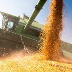
For the grains industry, the bumper grain crop predicted for 2021 has already been downgraded in areas like New South Wales due to flooding, with losses expected to be in the billions.
By contrast, the beef industry in Queensland relies on grass, so a La Niña summer with above-average rain can increase pasture growth and regeneration as well as cattle weight gain and market prices.
This double-edged sword – too much rain or not enough – is nothing new to Australian farmers.
Understanding how La Niña and other ENSO (El Niño-Southern Oscillation) events impact different regions and industries is critical to take advantage of good years, minimize losses in poor years, and make sound decisions based on the best possible information.
What does that look like? In La Niña years, cattle farmers may decide to move their cattle out of flood-prone regions or rest a paddock to allow it to regenerate with the extra rain, which will provide more grass in the following season.
For grain farmers, La Niña means keeping a close eye on both three-month seasonal climate forecasts and the daily weather forecasts to decide if it’s worth the risk to plant a big crop and if they are likely to be able to harvest it before any big rainfall events occur.
La Niña events usually bring average to above-average rain to much of Australia’s east. Unfortunately, no two La Niñas occur in the same way.
Because of this variability, it is important for farmers to understand how La Niña events impact their area so that they can plan for likely conditions.
Australia’s east coast climate is heavily influenced by the El Niño-Southern Oscillation (ENSO), a naturally occurring phenomenon centred in the tropical Pacific that consists of three separate phases: La Niña, El Niño, and a neutral or inactive phase.
La Niña years occur around 25 per cent of the time, with El Niño years also at 25 per cent, and neutral years making up 50 per cent. ENSO is not fully predictable, and moves irregularly between these phases. While it is unusual to have back-to-back La Niñas it is not unprecedented.
During these La Niña events, surface water in the central and eastern equatorial Pacific cools and the ocean to the north of Australia tends to warm.
Changes in the ocean drive changes in the atmosphere over the Pacific. Like a rock thrown in a pond, however, this Pacific phenomenon ripples outwards, causing atmospheric changes in places like Australia and Chile.
In Australia, La Niña tends to bring more rain and lower temperatures across much of the country, while we see increases in heavy rain, flooding, and severe tropical cyclones making landfall.
What does the future hold? While most La Niña events are projected to produce less rainfall in many regions, projections suggest the wettest La Niña years will tend to be just as wet or wetter than they were in the past.
Australia’s farmers will continue to face the challenges of floods and droughts brought by La Niña and El Niño, but as farmers learn more about these events and how they impact their area and industry, they can become more resilient.