“We’re a holding pond for Winnipeg.”
– LORNE HAMBLIN
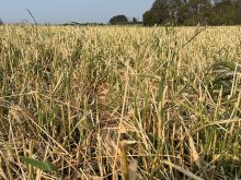
Thick, gooey mud squishes under Lorne Hamblin’s rubber boots as he slogs through a field which should be sprouting green shoots. Instead, it’s a sea of heavy muck caused by retreating flood water and made worse by an inch of rain the day before.
Hamblin stops, his boots sinking ankle deep in the gumbo, and scoops up a handful of leftover barley straw to expose a black expanse of sodden earth with the consistency of quicksand.
Read Also

Manitoba Beef Producers take aim at elk surge, feed losses from wildlife
Resolutions at last month’s Manitoba Beef Producers meeting seek help to rein in elk and deer populations, expand fencing supports and improve compensation for wildlife damage.
“This won’t dry out until fall,” he says.
It’s May 26 and Hamblin, along with most other farmers along the Red River, would normally be nearly finished seeding by now. Instead, some have hardly turned a wheel.
At peak around April 20, water from the swollen Red covered 236,000 acres of land, including most of Hamblin’s farm. The overland sea up to 14 miles wide marked Manitoba’s second-biggest flood since 1900 and the fourth largest since 1826. One of Hamblin’s neighbours was cut off by flood water and had to ferry a boat between his farmhouse and the road for five weeks.
HIGHER GROUND
Hamblin and other farmers along the Red are used to occasional floods. They well remember the 1997 Flood of the Century, after which Hamblin and his wife Chris finally abandoned their generations-old family farmstead on the west side of the river and moved their house to higher ground on the east side.
But producers say the frequency of floods has increased significantly since the completion of the Red River Floodway in 1968.
Affectionately called “Duff’s Ditch” after former Manitoba premier Duff Roblin who spearheaded the project, the floodway has prevented over $10 billion in flood damage to Winnipeg from the Red River, according to the Manitoba Floodway Authority.
But it’s practically an article of faith among farmers that raising the floodway gates to divert the flow around the city backs up water to the south for miles. This artificially floods fields and keeps water on the land longer, they say.
“We’re a holding pond for Winnipeg,” said Hamblin.
As of last week, Herm Martens, who farms at nearby Rosenort, hadn’t seeded an acre either. Half of his 3,000-acre farm was also under water for weeks this spring.
“We’re being asked to hoard a lot more water here than we should,” said Martens, who is also reeve of the Rural Municipality of Morris. “It is certainly not moving along like Mother Nature intended it to.”
CONTROL WORKS
The floodway is one of four flood control works built to protect Winnipeg from the Red River. The primary dikes along the river inside the city are the first line of defence. The other defences are the Assiniboine Diversion near Portage la Prairie, which diverts water from the Assiniboine River northward into Lake Manitoba, and the Shellmouth dam and reservoir on the upper Assiniboine, also built to reduce the risk of flooding along the river.
Farmers in the Assiniboine Valley periodically complain they too experience excess water from flood controls along their river.
Hamblin hauls out a Manitoba Conservation map titled “Impact of Raising Floodway Gates.” It tabulates the amount of upstream land flooded when the gates are raised. According to the map, the area totals 2,236 acres when the height of the water reaches 756 feet above sea level at the floodway inlet.
Hamblin considers this an admission by the province that the floodway really does make upstream flooding worse. “There’s no question they’re artificially flooding us,” he said.
The Hambl ins certainly don’t object to floodproofing Winnipeg. But they do suggest a special government compensation program for flooded farmers, based on input costs and potential crop losses.
Martens, whose ancestors came to the area in 1874, said farmers shouldn’t be told to accept flooding without compensation when, in his view, man-made structures contribute to it.
REJECTS CLAIMS
Steve Topping, Manitoba Water Stewardship’s executive director of infrastructure and operations, flatly rejects farmers’ claims that the floodway caused excessive, prolonged flooding on farmland this spring.
“For the 2009 spring flood, we operated the floodway to the state of nature. In other words, no artificial flooding occurred upstream of the floodway,” said Topping.
According to the province, “natural level” means the water level that would be expected in the Red River during spring flooding without control measures. That was the case this year, Topping said.
“If the floodway, the Portage Diversion and the Shellmouth reservoir were not in place, we would have seen the same water levels.”
In 1997, the control structure did cause some artificial flooding of land upstream of the floodway, but not this year, said Topping.
He said Hamblin’s map only indicates the level of flooding expected on land under natural conditions and does not refer to artificial flooding.
Topping said the Red River Floodway Act does compensate land and property owners, including farmers, for damage caused by artificial flooding above and beyond the federal-provincial Disaster Financial Assistance (DFA) program.
COMPENSATION
For example, farmers and landowners received over $1 million in 2005 when an unusually wet summer forced officials to engage the floodway to protect Winnipeggers from basement flooding resulting from storm sewer backup. Most of the money went to market gardeners along the river who lost crops.
Similar compensation for summer flooding occurred in 2002 and 2004, Topping said.
Provincial flood officials say the increased frequency of flooding along the Red River is the result of a wet cycle which, since 1996, has produced four of the five largest floods in Manitoba in 100 years.
Locals claim increased drainage projects in the Red River watershed cause water in spring to run off the land faster than it should, adding to the flooding problem. Topping doesn’t buy that argument either.
“In these very large spring flood events, the flood overwhelms the drainage system.”
INSURANCE IMBALANCE
Hamblin has another beef, this one with crop insurance. Because he owns land both inside and outside the Morris flood dike, his crop yields can vary widely whenever there’s a flood.
For example, in 1997 his Barrie wheat produced 45 bushels an acre inside the dike, where it was dry, and 17 bushels an acre outside the dike, where flooding occurred.
Crop insurance should allow farmers to insure fields individually for production, as they can for hail damage, Hamblin said.
But insur ing individual fields instead of total acreage would increase risk and make premiums unaffordable, said Craig Thompson, the Manitoba Agricultural Services Corporation vice-president of insurance operations. “The risk goes up astronomically on a field insurance basis,” Thompson said.
“We’ve looked at it and what the farmer would have to pay and what the two levels of government would have to pay in premiums would put it out of reality. People wouldn’t pay that type of premium.” [email protected]